Macclesfield Then & Now
Switch between old Ordnance Survey maps of the town, from around 1900 and the 1950s, and a map of today, or put two side by side. Ten stops tell the story of the silk town: tap one to read it, or walk the route yourself.
Ten stops in the story of the silk town
The stops run in walking order, from West Park to the canal: about 2.5km, mostly downhill, with the 108 Steps in the middle. Allow an hour and a half with time to look.
-
1 · 1898
West Park Museum
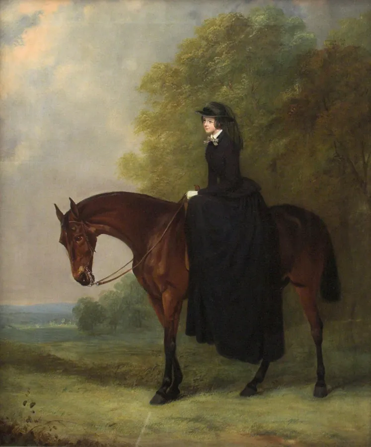
The museum's founder, Marianne Brocklehurst, aged about 21, painted by Henry Calvert around 1853. Henry Calvert, c.1853. Public domain, via Wikimedia Commons Then: Find the corner of West Park by Prestbury Road, where the museum was built in 1897–98.
Marianne Brocklehurst, a silk manufacturer's daughter, travelled in Egypt from the 1870s and helped to pay for early excavations there. She and her brother Peter Pownall Brocklehurst gave the town this museum, which opened in 1898 to hold her collection, "for the education, refinement and pleasure of the people for all time to come".
Now: The building is closed to visitors for now because it isn't a safe place to keep old objects, and the whole collection has moved to the Silk Museum, so you can still see it in town.
-
2 · 1775
Christ Church
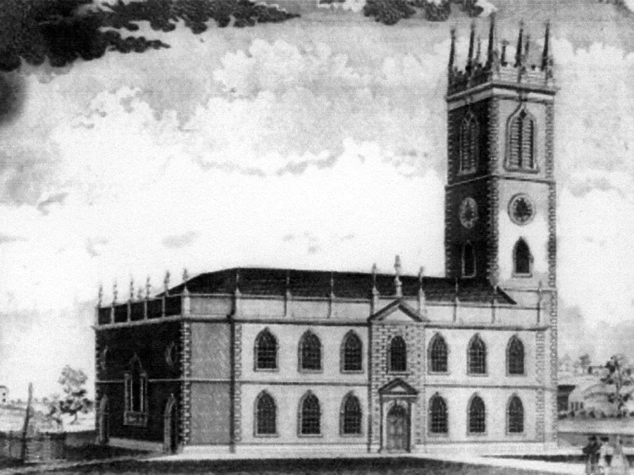
Christ Church in an engraving from 1838, its tower already towering over the town. Engraving, 1838. Public domain, via Wikimedia Commons Then: Already 125 years old on the 1900 map, standing in its graveyard among rows of terraced streets.
Silk and copper businessman Charles Roe built Christ Church for the preacher David Simpson after Simpson fell out with St Michael's. It went up astonishingly fast: work began at Easter 1775 and the church opened that Christmas. The tower, added the next year, is about 33 metres (107 feet) high, said to be built to rise above St Michael's. John Wesley preached here, and Roe's memorial inside shows his silk mill and copper works.
Now: Regular services ended in 1981. The church is Grade II* listed and is looked after by a national churches charity, opening for events and the occasional service.
-
3 · 1814
The Old Sunday School
Then: Find Roe Street: the Sunday School is one of the biggest buildings along it.
Paid for by public subscription and finished in 1814, the "Big Sunday School" taught working children, many of them from the silk mills, to read and write on their one day off. When it opened it had more than 2,400 children on its books.
Now: It closed as a school in 1973 and was saved from demolition in the 1980s. It's Grade II* listed and still in use, with an independent cinema and a small exhibition about its history.
Have an old photo of The Old Sunday School? Send it in and it could appear here with your name on.
-
4 · 1862
Paradise Mill
Then: Look for the long mill buildings on Park Lane, with streets of houses packed in around them.
The upper mill dates from the 1820s and the lower mill from 1862. From 1891 it worked only in silk, and by the 1930s its top floor held 70 hand looms, each weaving patterns guided by punched Jacquard cards.
Now: The firm closed in 1981 with the looms still in place. It's now a working museum with 26 restored Jacquard hand looms, thought to be the largest collection in their original setting in Europe.
Have an old photo of Paradise Mill? Send it in and it could appear here with your name on.
-
5 · 1743 · Lost
Park Green and the first silk mill
Then: Park Green is ringed with mills on the 1900 map, the busy heart of the silk town.
In 1743–44 Charles Roe built a small water-powered silk mill at Park Green, copying the famous Lombe mill in Derby. It's often called the start of Macclesfield's silk industry, which grew to fill the town with mills and gave it the nickname Silk Town.
Now: Roe's first mill is long gone; local histories say it was pulled down in the 1960s. Later silk mills still stand around the green.
Have an old photo of Park Green and the first silk mill? Send it in and it could appear here with your name on.
-
6 · 1824
The Town Hall
Then: Labelled "Town Hall" on Market Place, right beside St Michael's, with the Shambles market just to the north.
A medieval guildhall once stood here. Francis Goodwin designed the present building in Greek style, modelled on the Erechtheion in Athens. Its foundation stone was laid on 4 September 1823 and it was finished in 1824. Local architect James Stevens enlarged it around 1870.
Now: Still the Town Hall, and Grade II* listed, with a modern extension added around 1990.
Have an old photo of The Town Hall? Send it in and it could appear here with your name on.
-
7 · 13th century
St Michael's and the 108 Steps
Then: Find St Michael's Church, then the narrow path that drops steeply from the churchyard down to Waters Green.
There's been a church on this hill since the 13th century, though St Michael's has been rebuilt many times. Behind it, the 108 Steps, once known as School Brow or School Bank, link the old town on the hill with Waters Green below. They've been climbed for centuries.
Now: Legend says that if you climb all 108 without taking a breath, your wish comes true. The cobbles were relaid in 2014 after a campaign by local people.
Have an old photo of St Michael's and the 108 Steps? Send it in and it could appear here with your name on.
-
8 · 1873
Waters Green and Central Station
Then: Waters Green sits at the foot of the hill. Just across the tracks is "Central Station".
Charles Roe built a second, larger silk mill on Waters Green in 1748. More than a century later the railway arrived in the valley, and Central Station opened in 1873, one of two stations then serving the town.
Now: Central is the station you use today. Its neighbour, Hibel Road, closed in 1960: see the next stop.
Have an old photo of Waters Green and Central Station? Send it in and it could appear here with your name on.
-
9 · 1849–1960 · Lost
Hibel Road Station
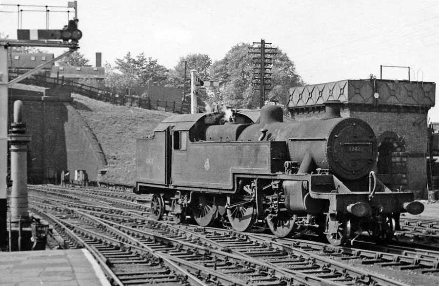
A steam engine at Hibel Road Station on 13 June 1959, looking north towards Stockport. The station closed the next year. Photo © Ben Brooksbank, CC BY-SA 2.0, via Wikimedia Commons Then: Look north of Waters Green for "Hibel Road Station", with the goods sheds, engine shed and sidings fanning out beside it.
Hibel Road opened on 13 July 1849, shared by two railway companies whose lines met here end to end. For more than 80 years Macclesfield had two stations less than 500 yards apart.
Now: Hibel Road closed on 7 November 1960, leaving the old Central as the town's only station. Compare the 1900 map with today to see how much of the railway land has gone.
-
10 · 1831
Hovis Mill and the canal
Then: Follow the canal as it curves along the east side of town, with mills along the towpath.
The Macclesfield Canal was dug between 1826 and 1831, one of the last narrow canals built in England. In 1887 Richard "Stoney" Smith patented a flour that kept the wheatgerm in and went into business with the Macclesfield millers S. Fitton & Sons. In 1890 a competition gave it a name: Hovis.
Now: The canalside mill, still called Hovis Mill, has been turned into flats. The canal is a quiet walk now, and part of the Cheshire Ring.
Have an old photo of Hovis Mill and the canal? Send it in and it could appear here with your name on.


Know more about these places?
Did your gran work at Paradise Mill? Do you remember catching a train at Hibel Road? Send a memory, an old photo you own, or a correction, and the best ones will be added to the map with your name on.
About this map
Macclesfield Then & Now is a free local history project from Lime Fresh Design, a web design studio in Macclesfield. It's our way of giving something back to the town, and a small example of what a website can do for a museum, a history society or a local attraction.
Old maps: Ordnance Survey 25-inch, Cheshire, about 1900, and OS 1:10,560 National Grid, 1950s–60s, courtesy of the National Library of Scotland (CC-BY). Today: © OpenStreetMap contributors. Old pictures: Christ Church engraving, 1838, and Henry Calvert's portrait of Marianne Brocklehurst, c.1853 (both public domain); Hibel Road Station, 1959, © Ben Brooksbank, CC BY-SA 2.0; all via Wikimedia Commons. Map: Leaflet. Dates and facts are from Historic England listings and published local histories; where sources disagree we've said so.